 Coulterville was settled in 1850 by George W. Coulter, for whom it is also named. For a time Coulter lived in a tent flying the American Flag, prompting local Mexicans to call the place Banderita (Spanish for "small flag"). The Maxwell's Creek post office opened in 1852 and changed its name to Coulterville in 1853. The name Maxwell honors George Maxwell, with whom Coulter cast lots to determine the name of the town.
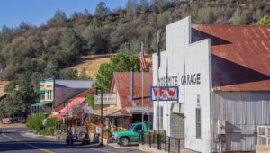
Coulterville is registered as California Historical Landmark #332. A large portion of the downtown was listed on the National Register of Historic Places as the Coulterville Main Street Historic District.
The 1867 Brevet General James F. Rusling inspection report notes that most of the Stockton to Coulterville area was "in almost continuous wheat-fields" May 24th - 26th, 1866. The intersection of California State Route 49 and California State Route 132.
Coulterville (formerly, Maxwell's Creek) is a census-designated place in Mariposa County, California. It is located on Maxwell Creek 20 miles (32 km) northwest of Mariposa, at an elevation of 1699 feet (518 m). Coulterville had a population of 201 at the 2010 census. It is a former mining town located in the foothills of the Sierra Nevada.